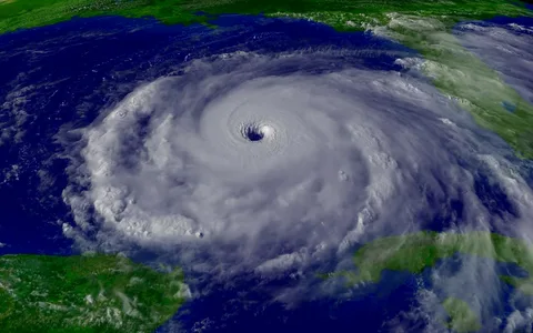
A meteorologist is an expert in weather who studies the atmosphere and its processes to better understand the environment around us. As such, they are well-equipped to track hurricanes, which are powerful storms that can cause destruction to property and people. Meteorologists use a variety of tools to track the progress of hurricanes, such as satellites, radar, and forecasting models. By studying the data from these tools, they can accurately predict the path of a hurricane, as well as its intensity and potential effects. By tracking hurricanes, meteorologists are able to provide valuable information to help people prepare for the storm and stay safe.
Climatology Data
Climatology data is a collection of past weather data and present observations used to analyze and predict current and future weather conditions. It includes temperature, rainfall, wind speed and direction, humidity, and atmospheric pressure readings, along with other atmospheric data collected over time. This data is used to create models that can accurately forecast the path and intensity of hurricanes. Meteorologists use this data to develop models that accurately predict the track of a hurricane, as well as its strength and potential effects. This data can also be used to create forecasts for other natural disasters, such as floods, droughts, and tornadoes. By utilizing climatology data, meteorologists are able to provide life-saving information to help communities prepare for and stay safe during a hurricane.
Forecasting the Storm’s Path Using Weather API
Meteorologists use a variety of tools and techniques to forecast a hurricane’s path, including weather APIs. Weather APIs (Application Programming Interface) are a type of software that allow for the retrieval and exchange of weather data. These APIs provide access to a range of real-time weather data, such as wind speed, air pressure, temperature, and precipitation. Meteorologists use this data to construct weather models, which are used to accurately predict a hurricane’s path. By accessing real-time weather data from a variety of sources, meteorologists are able to create models that accurately forecast the path of a hurricane. These models are based on the current state of the atmosphere and can be used to determine the likely path of the storm and its potential effects. By using weather APIs, meteorologists are able to provide up-to-date and accurate forecasts to help people stay safe during a hurricane.
Wind Forecasts
Meteorologists use a variety of instruments and techniques to provide predictions regarding the speed and direction of hurricane winds. Aside from satellites, radars, or supercomputers; they turn to data gathered by their own observations as well. By carefully analyzing such information from these resources meteorologists can accurately predict the path taken by coming hurricanes with great precision – allowing for preparation in advance should any wrecks occur along their courses.
Wind speed and direction, as well as their variability across time can be utilized to predict storm surge – the elevated ocean level of water caused by a hurricane. Predictions of wind speeds and directions during an impending hurricane can help individuals make preparations for any impacts that may occur; additionally, they assist in formulating evacuation plans should such conditions arise. Wind forecasts provide valuable insights into how long a given storm will last along with notable areas susceptible to damage or loss of life-supporting infrastructure. This crucial information is invaluable in tracking and forecasting hurricanes for both survival purposes & providing lifesaving data for those living within its vicinity.
How Hurricanes Are Categorized
Hurricanes are categorized by their intensity, which is based on the maximum sustained winds they produce. Category 1 hurricanes are the weakest, with maximum sustained winds between 74-95 mph. They are typically accompanied by minimal damage, such as minor roof and tree damage, and power outages.
Category 2 hurricanes have maximum sustained winds between 96-110 mph, and they can cause moderate damage, such as broken windows, downed trees, and power outages. Category 3 hurricanes have maximum sustained winds between 111-129 mph and can cause extensive damage, such as structural damage to buildings and downed trees.
Category 4 hurricanes have maximum sustained winds between 130-156 mph and can cause catastrophic damage, such as structural damage to buildings, flooding, and power outages. Finally, Category 5 hurricanes have maximum sustained winds greater than 157 mph and can cause catastrophic damage, such as complete destruction of homes, major flooding, and widespread power grid damage. By categorizing hurricanes based on their intensity, meteorologists can provide more accurate forecasts and help people prepare for the storm.
By using real-time weather data from a variety of sources, meteorologists are able to create accurate models that forecast the path of a hurricane. Wind forecasts are a critical part of this process, as they provide insight into the intensity and direction of the storm. By predicting the wind speeds and directions associated with a hurricane, meteorologists can help people prepare for the storm and form evacuation plans.